Extracting Terrain to MPT
The Extract Terrain tool extracts and creates a subset of a local or remote terrain database.
Using the Extract Terrain tool, you can create a terrain database for distribution using an external storage device or even create a local MPT from a DirectConnect project.
The extracted terrain is built from a high-resolution polygon, a medium resolution rectangle surrounding the high-resolution area and a low-resolution area that always covers the entire terrain. You can control the size of the high- and medium-resolution areas and control the quality of all three areas.
Note: Because the low-resolution area always covers the entire source terrain database, although it can be set for a very poor quality to save storage space, the original FLY project always runs on the new terrain database and all locations and objects have valid coordinates in the extracted terrain.
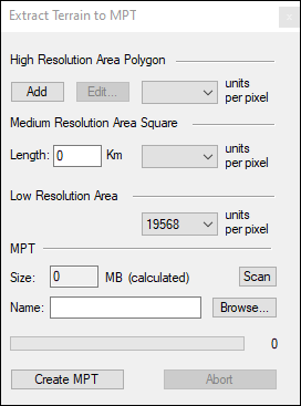
Extract Terrain to MPT Tool